The Island

| Route 66 | Cities | Beaches |
|
The Island |
|
|
Melville
Coast |
Nantucket |
The Ferries |
Lodging |
Restaurants |
Bicycling |
The Town |
On The Water |
Surely Nantucket is one of the biggest small islands in the world. It's only three miles by 14 miles and from the town of Nantucket you can ride a bike to any point on the island in half a day. Yet there are eight different kinds of beaches, open ocean, isolated and smooth as glass harbors, heaths, the largest cranberry bog in the world, seal colonies, picturesque villages, wilderness areas, a university research center, America's largest hydrangea farm, cliffs, farms, sanctuaries, old Native American sites, and a thick maritime forest inhabited by wealthy recluses. You could spend a summer here surfing. or sailing. Or biking. Or fishing. Or painting. Or birdwatching. Or cranberry farming. Or photographing. Or studying one of the various ecosystems the island contains. Or you could do all of the above. In a week, or, even worse a couple of days, there isn't time to do much except quickly sample a little of what the island has to offer, then plan to come back on another occasion and stay long enough to get truly acquainted. |
 |
 |
The best way to start getting acquainted is to pedal straight South out of town on Surfside Bike Trail. To hit this trail, just follow Main Street up to Pleasant Street, follow it East to Atlantic Avenue, and head South. After one block, the bike trail begins and parallels the road all the way to Surfside Beach. Along the way, you'll pass Nantucket elementary, middle and high schools. Once you reach the top of Main Street Hill, the terrain on this cruise is gently rolling all the way. Halfway out is a drinking fountain and bench. You'll never be truly out in the country, as the entire 3 miles is basically a suburb of Nantucket. Eventually you'll reach Surfside Beach, with the Youth Hostel just to your right, or West. There's a bike rack, bath house. lifeguards, snack stand, and rest rooms. Surfside Beach is shown to the left. It is a beautiful beach, facing open ocean due South. The sand is fine and clean, the slope very gradual. The water here is usually calm, diue to a long shallowing up of the shelf offshore. This is a good beach for family outings, but the water is usually 10 degrees colder than that on the northern side. There are lifeguasrds. |
| This is Cisco Beach, just West of Surfside. There is no formal bike trail out to Cisco. To get there, follow Main Street up to Milk Street, and just stay on Milk. It turns into Hummock Pond Road which in four miles reaches the loose village called Cisco. This ride is slightly more rolling than Surfside but still a pleasant cruise. There are lifeguards and bike racks but no snack stands. |  |
 |
For hardcore surfing or playing in the surf, go out to Madaket Beach. This is a longer ride. Follow Main Street up the hill and it becomes Madaket Road. The ride from downtownto the beach is 6.2 miles. The terrain toward the Western island becomes more uneven, so you'll have to climb a few legitimate hills. The scenes immediately below give you an indication of the landscape toward Madaket. This beach is famous for having the most beautiful sunsets on the Atlantic coast. You are looking southwest and Nantucket is far enough out that neither Long Island nor Martha's Vineyard can be seen. It is a very long beach and lifeguards are stationed only at the Eastern side. |
|
On the North side of the island, Dionis Beach is 3.4 miles out of town. Just take the Madaket Road to the intersection with Eel Point Road and turn right/north. Dionis faces Nantucket Sound rather than the open ocean, so the wind is opposite. When the surf is coming in heavy on the South, the water is often calm here, but you have to watch as the drift may be offshore. When the water is calm on the South, Dionis often looks like this photo. You will find different shells here because of the more shallow Sound water. Temperatures on this North side will average 10 degrees warmer. If you pass this beach and continue pedalling out Eel Point Road, you will come to Eel Point. This is not good for swimming because of the dense stands of eel grass, but is the best shell collecting location on Nantucket or anyplace else in this part of the Atlantic. You will find shells here that are simply not present elsewhere, and you will find more shells than elsewhere. If you are coming out to look for shells, bring a few plastic bags. |
 |
 |
This is Cliff Beach. You're only two miles from downtown here, so it's a popular beach. To get here, pedal to the Whaling Museum, head North on Beach Street, and follow it all the way to the bike racks, bath house and public rest rooms. |
In your walks or rides around town, locate The Rotary. This is a circular intersection patterned on the ones in England. The Rotary is where rides to the Eastern side of the island begin. Only a short distance out Milestone Road from The Rotary, Polpis Road turns off to the left. Take this road. It will be a 10 mile ride to Siasconset. The first attraction you will come to is the Nantucket Hydrangea Farm. Even if you're not especially interested in gardening or flowers, you might want to stop for a visit. This is the world's largest Hydrangea breeding operation, a place for collectors to obtain various kinds of hydrangea, and a place to study hydrangea. The Miniature Hydrangea was bred here. The Hydrangea originated on the Japanese islands, and Nantucket has exactly the same conditions as they do, so Hydrangea thrive here. |
 |
 |
Further out along Polpis Road, you'll come to the cranberry bog. This is the largest contiguous cranberry bog in the world, and is very much in active cultivation. The plants actually grow under water and as the cranberries ripen they float to the top. The photo at the very top, right, shows a harvester in knee deep water. The berries are brought to shore and dumped in machines like the one shown at left. It sorts them for processing. Ocean Spray, the great Puritan company founded in 1625 to process cranberries for shipment back to England, is still the largest purchaser of cranberries in the world, and purchases most of these. They are marketed as cranberries, cranberry sauce, cranberry jelly, cranberry juice and cranapple juice. Cranberries are known anticarcinogens, antioxidents, and a prime source of several vitamins. |
| Eventually you'll pedal into this amazing scene. The oceans are indeed rising (remember Global Warming??) and the part of Nantucket they're most threatening is the far Eastern coastline. This is Sconset Lighthouse and the northern houses of the town of Siosconset. Homes, roads and even the lighthouse are endangered. To cope with this, short term solutions are being tried like repleneshing and rewidening the beach with sand pumped off from further offshore, but in the long run, something as big as an ocean cannot be held back with a small amount of pumped sand. Just as the famous Hatteras Lighthouse in North Carolina had to be moved much further inland, discussions are beginning about whether or not to move this lighthouse. The cliff line begins dipping to the left (south) of this photo, and much of the town is not as high. The beach widens, with lifeguards and rest rooms. A small store is nearby. |  |
 |
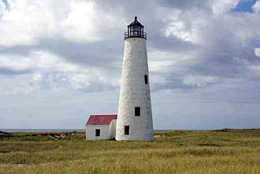
This is the Great Point Lighthouse, furthest North extreme of Nantucket Island. It is up the coast from Siasconset, but you can't get here by bike. There's neither bike path nor road. You have to use a four wheel drive vehicle. Some outfitters in town will take you out for a fee. Theoretically, you could hike it, but it would be about 10 miles along the beach from Siasconset. It would make a reasonable two night backpacking trip, with a one day hike out, one day spent exploring the area, and a one day hike back. You would pick up a beach permit from the office back in Nantucket, if you can talk them into letting you camp out there overnight, which is theoretically forbidden. We have known certain groups to obtain permission by writing in advance, and we've done it, but we've known others who were turned down. To return to Nantucket from Siasconset, take Milestone Road from the southern end of town. This route is 8.2 miles, and parts of it are downhill, as the Eastern coast of the island is higher than the area around the harbor. |
|
|||
|