Charit Creek
| Route 66 | Cities | Beaches |
|
Charit Creek |
|
| Shakertown |
| Want to take your group backpacking, but they're tired of
eating freeze dried food, carrying 30 pound packs, and sleeping on the ground
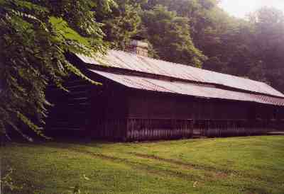
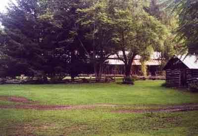
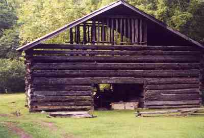
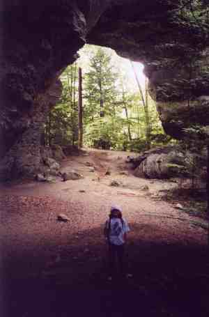
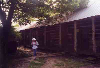
? Or just want to mix a little history with your next wilderness adventure ? Put Charit Creek Lodge in the Big South Fork on your schedule. The place is dripping with history. The main lodge was built in stages in the early 1800s. The corncrib, huge barn, stables, kitchen and bath house were added over the next century. As other families up and down the valley abandoned their homesteads, their log cabins were numbered, dismantled, moved to Charit Creek and reassembled for various offspring and their families. The farming operation was abandoned in 1963, and the buildings were operated as a bear and boar hunting lodge until 1983. When the National Park Service closed that use, it became a youth hostel for 20 years. For the last decade it has been a back country lodge. You cannot drive to Charit Creek. The only access is by hiking or horseback. |
There are several trails coming in, but the shortest is from
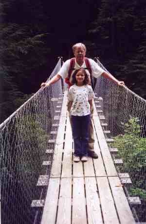
the Charit Creek Trailhead. It is a steep one mile descent through beautiful
old growth forest strewn with house sized boulders, cliffs and ferns, and
concluding with an impressive swinging bridge over Station Camp Creek. You can stay at Charit Creek Lodge as a camper or hostel guest, meaning you cook your own meals, but by far your best arrangement is as a full guest at $75 a night. This means a $150 weekend. You get dinner Friday night, three meals Saturday, and breakfast Sunday. The meals are served family style in the lodge dining room. They are hearty and all you can eat. A typical dinner might be chicken and dumplings with three heaping bowls of vegetables, plus a rich dessert. Breakfast is usually pancakes, eggs and bacon, coffee or hot chocolate, biscuits and grits. Most guests take a sack lunch to eat on the trail. Those include a bag of trailmix, an energy bar, and your choice of ham, turkey or peanut butter & jelly sandwich. |
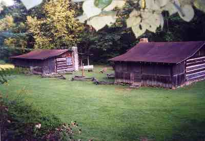
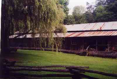
| You can stay in either the main lodge or one
of the outlying cabins. Both feature bunkbeds and screened in porches. These
are great bunkbeds, with firm mattresses. Charit Creek offers the only queensized
bunk beds we’ve ever seen, so couples needn’t feel lonely. The restrooms and hot showers are practically brand new and are very clean, spacious and modern. There are rocking chairs and game tables on the porches, plus horseshoe pits, hammock and a volleyball court. You even have entertainment of sorts, thanks to three cats, two dogs and a marvelous flock of hummingbirds which spend the day darting and wheeling around feeders. Charit Creek has no electricity except a small amount generated by solar energy. Oil lanterns are everywhere. There is no telephone and cell phones don’t work. From most of Kentucky, your best access is through Monticello. Drive down I-75 from Lexington, take the cutoff at Mt. Vernon, follow 80 to Somerset and 90 to Monticello. Or come across I-66 from Bowling Green and pick up 90 at Somerset. |
 |
|
From Monticello, take 167 through
Pickett State Park and turn left on Divide Road, a gravel stretch of 10
miles. Turn right onto Twin Arches Road and park at the trailhead. Your
car will be safe. From Lexington or Bowling Green the driving time to the trailhead is about three hours. We tried the Oneida and Huntsville entries and they took longer. If you make your arrangements far enough in advance, you can pay by credit card over the phone. But if you make them the week of your arrival, you will need a check to present to the lodge, since with neither electricity nor phone service they cannot accept credit cards. Charit Creek Lodge is administered by the NNThe Woods LLC. . The phone for reservations is 1-931-879-2776, 8-5, Monday through Saturday. There is also a web site, charit creeklodge.com. Your best option is a three night stay. The first night you can drive to the trailhead and hike down, making sure to arrive by 6 pm for dinner. If you come in too late for that, they will make it up with a full hot lunch on the day of your departure. |
| The first full day, hike the Twin Arches Loop
Trail. Take the Big Jake’s Place side of the loop on the way up. Big
Jake Blevins arrived in the late 1700s and established his farm high on
Station Camp Creek. The foundation and chimney, plus the clearing, remain.
Jake’s son, John, moved two miles down the valley to where Charit
Creek comes into Station Creek, and built what it now the lodge. The trail,
however, climbs on past rockhouses, cliffs and overlooks to Twin Arches,
one of the Big South Fork’s premier attractions. If considered one
entity, this is one of the largest natural arch formations in the world.
Either one would rival Natural Bridge or anything in Utah’s Arches
National Park. There are larger arches, but they are often slender, graceful spans. These are massive. A stairway climbs to the top, where the trail leads across both. There’s even a cave going all the way through to the right of South Arch. Iron rings mark the sides. This is a great lunch stop. Bring a camera and plenty of film. If Twin Arches were anywhere else, it would be the centerpiece of its own state park. There is a short but challenging loop trail which heads north from North Arch, climbs several flights of stairs, comes out on the ridge, and turns left to come out back atop North Arch. For the return trip, however, take the trail heading southeast from the base of the stairway right at the Arches, and descend steadily into Charit Creek Valley. Only one cliff face lines this trail, with several rockhouses, but the forest is beautiful, and with a closeup lens you could illustrate a whole guide to fungi and mushrooms. You’ll see every color and species. The trail is also lined with Ebony Spleenwort and New York ferns. On the second full day, hike up to Slave Falls for lunch. You could take the horse trail up, but you’ll need to wade Station Camp Creek. To avoid this, follow the hiking trail back up to Big Jake’s Place and turn left. |
 |
 |
You’ll have a bridge over Station Camp
Creek and then a steady climb to the falls. This is an 80 foot drop with
a large rockhouse behind and very scenic. In dry weather the water narrows
to a ribbon, but with normal rain, it pounds down in a roadwide sheet. Shoot
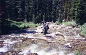
a roll of spectacular scenes from behind the falls on a sunny day. These are not the only trails available. But these are the ones for hikers, and they are meticulously maintained by the National Park Service. They all head west of the lodge. Heading east are longer trails, but they present several problems. First, they are open to horses, and have been churned into a mess, like a scree slide in dry weather and a quagmire after rain. You are required to do exactly what hikers are not supposed to do : move off the trail to the right or left to find solid ground, thus steadily widening the right of way. Otherwise, you will sink calf or knee deep in a very sticky black mud. You will hit a stretch like this every eighth of a mile or so. And in skirting the swamps, hikers encounter poison ivy, ticks and chiggers. Second, these trails are not as well maintained or marked. You have trails on the official maps which are not signed, and you have signs pointing to trails which are not on the maps. Sorting this out becomes difficult, especially down by the river. Third, Station Camp Creek Trail is the main return route for various loops, and it requires seven stream crossings. Three of these are ankle deep, but two are knee deep and two are waist deep. The water is not cold or fast moving, so the crossings are not dangerous. But the bottoms are loose, shifting, sharp rocks, and barefooting it is nearly impossible. If you plan to do these crossings, bring a pair of river shoes. All of the crossings are within a two mile stretch, so you can conveniently trade shoes, then dry off and trade back. |
All of this considered, if
you have the time and want the challenge, these trails are interesting.
The two major highline trails are Fork Ridge and Hatfield. They both feature
strenuous mile long climbs, three mile straight stretches, and precipitous
mile long descents. Hatfield Trail brings you down directly at the river.
Fork Ridge brings you down on the floodplain, then crosses it for a mile
to the Hatfield intersection. You are then at Station Camp Crossing, where the creek empties into the Big South Fork, the river widens, and three islands span the water, providing the main horse crossing. This is where riders get from the western to the eastern side of the park, so almost all trails converge here. It’s great for horses, but it creates a churned mess for hikers. However, Station Camp Crossing is scenic, and a fine lunch stop. Whether or not any horses cross while you’re there, vistas are up and down the canyon are superb. Fork Ridge is a first hand demonstration of the destruction the pine beetle is causing in national forests. It has left tons of timber down. |
 |
 |
You are hiking for three miles
through a tinderbox of deadwood accumulated 12 feet deep in all directions.
Two straight wet summers have postponed the inevitable, but perhaps this
is what Bush had in mind when he recommended allowing timber companies
to clean out the debris. If we have a hot, dry summer, we may see a Big
South Fork conflagration equal to anything out West, and the terrain is
much more difficult. Hatfield Ridge is not quite as bad, but it’s
close. Fork Ridge offers another challenge : The Descent. You know you’re
in trouble when the sign warns riders to dismount and lead their horses.
Two riders passed us and half a mile later met us coming back. “We couldn’t make it,” they said. “Too steep. We can’t risk our animals like that.” On foot, we made it, but not without effort. The NPS could have just installed a staircase all the way down and defined this as a backpacking trail. But in trying to please the equestrian lobby, they instead installed tight switchbacking railings, broader steps, and red dog fill. Several places they left chutes between switchbacks. Struggling animals have churned these to mush, so hikers end up swinging down from tree to tree. And these alternating switchbacks and chutes go on for a mile. We regret that we did not get to see some experienced horses and riders navigate The Descent. It would have been photogenic. |
|
Once down at the river, the obvious route
back to Charit Creek Lodge is straight up Swift Camp Creek Trail, but
that leads to those horse churned marshes and seven stream wadings. An
alternative is Laurel Fork Trail, which crisscrosses the stream but requires
merely rock hopping. It also adds three miles to the loop. So : You could come down one of the highline trails and return the other, or come down one of the highlines and go back one of the valley routes, or if you’re really a glutton for punishment, come down Laurel Fork and return via Station Camp Creek. Whichever combination you choose, if you want to hike Station Camp Creek, always do it as a return, so you get your feet wet within two miles of the lodge. The Fork Ridge – Station Camp Creek loop is 10 miles if you go all the way to the river for lunch, then retrace your steps about a mile. Fork Ridge – Hatfield Ridge and Fork Ridge – Laurel Fork are 12 miles. Hatfield Ridge – Laurel Fork is 13 miles. The Hatfield Ridge – Station Camp Creek loop is 10 miles. But remember these are all hard miles, with strenuous mile long climbs, hairy mile long descents, and horse churned quagmires. |
 |
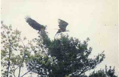 |
You might also choose any of these trails for after dinner wildlife strolls as dusk approaches. The canyon is full of game. The usual deer, coyote, possum, fox, muskrat and other Kentucky mammals are present. But copperheads, blacksnakes and rattlers are common. So are black bear and wild boar. And you may see eagles, hawks, owls, whippoorwills and other birds. If you’ve never seen a razorback hog this is the place to come.
You can see their tracks everywhere, especially around those horse churned
marshes, where they like to root for various delicacies. Sows are out
with their broods of hoglets. And the occasional male can be encountered,
with its taller back ridge, broader shoulders and longer tusks. Local
advice is to avoid stepping between the sow and her young, don’t
hike alone, and if you confront a male head on, make lots of noise, wave
your arms, and look for a tree to climb. |
The trails often pass through blackberry patches, which attract area bear. The usual rules apply : don’t hike alone, don’t step between a female and her cub, make lots of noise, don’t turn and run, and in a direct confrontation back slowly away while facing the bear, giving him a chance to posture and then retreat. Back at the lodge after dark, you’ll be entertained by fireflies, owls and bats. These can be viewed from the screened in porches. Insects are not a major problem at the lodge, but the bats seem to have plenty to eat as they swoop and dart around. Some of the fireflies are odd in that, unlike their yellow brethren, they glow white. The hosts change season by season. Currently, they are a trio of Knoxvillians : Jackie, a gorgeous Tennessee brunette who spends her spare time working on photography and art; Brian, a runner who spends his evenings after dinner pounding the trails in preparation for 27 mile marathons and hopes to save enough money to backpack Alaska; and Heather, a redheaded literature major who dreams of backpacking the British Isles. You could plan a trip to the Adirondack Loj, Glacier’s Sperry Chalet,
the Grand Canyon’s Phantom Ranch, Isle Royale Lodge, or the hostels
along the ridge of the Presidential Range up in New Hampshire. But those
are hard to book and far away. Charit Creek can usually be booked only
a week ahead and is the South’s best secret. |
 |
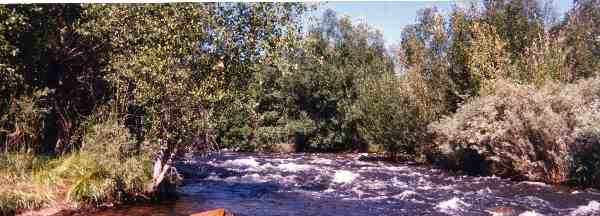 |
There is plenty of running water in the Big South Fork. You can book canoe trips or white water rafting trips through Rick Egedi at Sheltowee Trace Outfitters. If you can portage your kayak or canoe in to Charit Creek Lodge, you could paddle from the lodge down Charit Creek to the Big South Fork, although you'd have to portage back up to the lodge, which is a pleasant half day hike but would be quite a portage hauling a canoe or kayak overhead. Charit Creek is shown here at left. One of the modern inflatables makes more sense. Yopu can easily backpack one in to the lodge, since you don't have to bring a tent or cooking supplies. Backpacking the inflatable back up to the lodge after the run would also be easy. |
|
|||
|