Auxier Ridge
| Route 66 | Cities | Beaches |
|
Auxier Ridge
|
|
| Auxier Ridge | Martins Fork | Grays Arch | Rush Creek | Pinchemtight | KoomerRidge | ChimneyTopCreek | ParchedCornCreek | SwiftCampCreek |
| IndianStaircase | Castle Arch | Osborne Bend | Raven Rock | Red Byrd Arch | Indian Creek | Revenuers Ridge | Copperas Falls |
Auxier Ridge can be done as an easy overnight, an out and back, or a loop. We like it as a loop. Done that way, it becomes a classic all day adventure with great variety, photo ops, and a conditioning workout. We always do it as our second day hike of the season, which usually puts us there in early September, but it would be ideal as an October trip so the magnificent Fall leaf colors can be seen and provide photo backgrounds.. To reach the trailhead, come off the Mountain Parkway and turn right at the Shell Station onto state highway 15. Follow the winding road uphill 3.5 miles until it levels out, then look for the sign and turn left onto gravel Tunnel Ridge Road. To spare your vehicle, drive slowly. Continue for 4.5 miles. Turn right into the parking lot. As you enter the parking lot, the trailhead is to your left. |
|
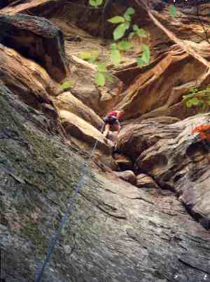 |
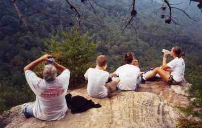
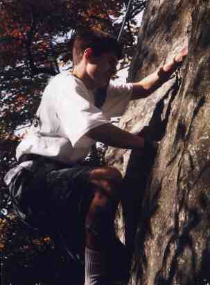
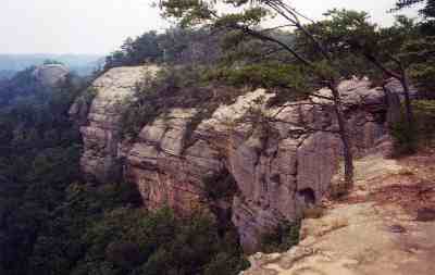
We always bring along an experienced climbing instructor familiar with this area and ask him to bring appropriate rappeling equipment. This is one of Kentucky's great rock climbing areas and a great place for beginners to try it under qualified supervision. Upon beginning the trail, you'll hike on the level for a short distance, then cut to your left and begin a wide arc through rhododendron forest. Keep your eye out for this sharp left, because other trails have been cut by climbers and photographers and you may find yourself following one of them to a sudden dead end, usually at the edge of a cliff. Once you complete the arc you'll come out on the ridge. The sides will narrow quickly, the trees will thin out, and you'll begin to glimpse some pretty impressive views on both sides. We always bring a pair of binoculars, because you'll see red tailed hawks riding the air currents and, especially on weekends, you may see other climbers dangling from ropes along the various rock faces across the valleys. |
|
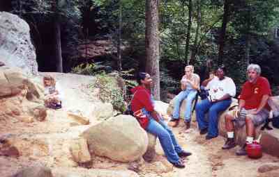
You may also pass several tents pitched off to your left or right, probably climbers out for a weekend of ropework. If you're on the trail early enough, you may see them fixing breakfast, but if it's midmorning or later, they'll probably be over the edge and somewhere down the rock face. These climbers have cleaned up from breakfast, taken down their tent, packed up, and are now enjoying a few more hours over the edge before hiking out and heading for home. We're watching them and taking a few photos. The soil out on this ridge is very thin and mostly sand, so the trees are almost all pines. Deciduous trees cannot survive here except in the occasional pockets of real soil. Many of the more exposed trees are also pretty gnarled from the high winds which occur during storms and all Winter. |
 |
 |
To your left is the Auxier Creek valley, which was totally timbered out early in the century. Just visible to the north is the Red River. Across the valley, to the West, is a good view of Double Arch in the distance and Haystack Rock much closer. Barely visible to the north, further out along the ridge, is Courthouse Rock. On the East side of the trail, looking down into the next valley, you have a good view of Raven Rock. High along the cirques of both these valleys, moonshining was once common, and hikers or climbers still find occasional remnants of the old stills. If you can take your eyes off the scenery long enough and look down, on any sunny day during three seasons you should see at least a few Skinks and Fence Lizards. The skinks are shiny black or brown with five gold or purple lines running the length of their bodies. The Fence Lizards are cousins to the more famous Texas Horned Toads. They have thriving populations on this ridge. |
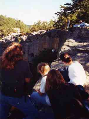
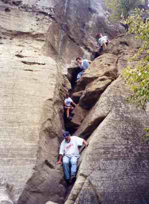
Eventually the going will get tougher, as you have to climb up about three feet to a ledge. You will then come to a wooden staircase leading down. At the base of that first staircase, you could turn left and head further down to the Double Arch trail, but don't. You need to stay on the level and follow the trail to the base of Courthouse Rock. You could go either way around the base, but if you head east, you'll climb about ten feet up a series of footholds in the rock, then squeeze around to a cleft in the cliff. You can climb this, with or without ropes. We think it easier and safer to do it with ropes. One of our experienced climbers, or a guide we have brought along, climbs up first and ties the rope to a tree or rock. But we've sat here and eaten lunch and watched other groups, one by one, climb the cleft by just leaning against the left rock face and pushing with their feet and hands against the right rock face. This is the beginners' route to the top of Courthouse Rock. There are other ways up for those with more skill and better equipment. Sometimes we'll climb up this cleft and the experienced climbers will lower ropes down the other side and we'll rappel back to the ground. It all depends on how much equipment we feel like bringing with us. It is, however, worth the effort. It's a great lunch stop. The 360 degree view is spectacular. There's always a slight breeze, so even on a hot July day it's comfortable up there. On a Spring or Fall day, it's great to lay down on the warm rock surface and either take a nap or just listen to the silence, interrupted by the breeze and the cry of Red Tailed Hawks or Turkey Vultures riding the thermal currents. It's a good place to work on a suntan. |
 |
 |
Once you climb back down the cleft and work your way around
to the stairs, you can descend to the right to Double Arch Trail.
This takes you deep into Auxier Valley, a second growth forest with
trees 70 years old. The trail drops to Auxier Creek, follows it
briefly, then begins to climb. A spur trail leads to
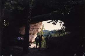
Double Arch. Take this spur. This is a beautiful small arch, very photogenic
with a little effort, and offering nice views. Once back on the main trail,
you have only another arcing climb and a final staircase, and you come
out at Road's End, the end of Tunnel Ridge Road. This last half mile of
road is now reverting back to trail, which you can follow back to your
vehicle. Before you do, however, you may wish to check the views to the
right and follow the trail down across the road from where you came up
from the stairs. This is the Western end of the Red River Gorge. You are
looking down on the farmland of the Red River Valley. |
| At Halloween 2010 three campers from Ohio started a fire on Auxier Ridge which they allowed to spread and ignite the forest. Before it was done, this fire blackened 3000 acres extending from Auxier Ridge all the way back to Martins Fork. Gorge trails and roads were closed for almost a month and the damage will be visible for a decade. The incident was especially infuriating to Gorge lovers because the area had endured a three month drought, the forest was tinder dry, and a ban on all campfires and cooking fires had been in effect for a month. However, unfortunate as the fire was, fire is a natural part of forest ecology, and Scout troops and school classes will have a tremendous opportunity to see how a forest recovers as they hike Auxier Ridge over the coming years. | 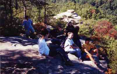 |
|
|||
|