| Route 66 | Cities | Beaches |
Backpacking |
Mules |
Rafting |
Cameron |
Havasu |
Sky Walk |
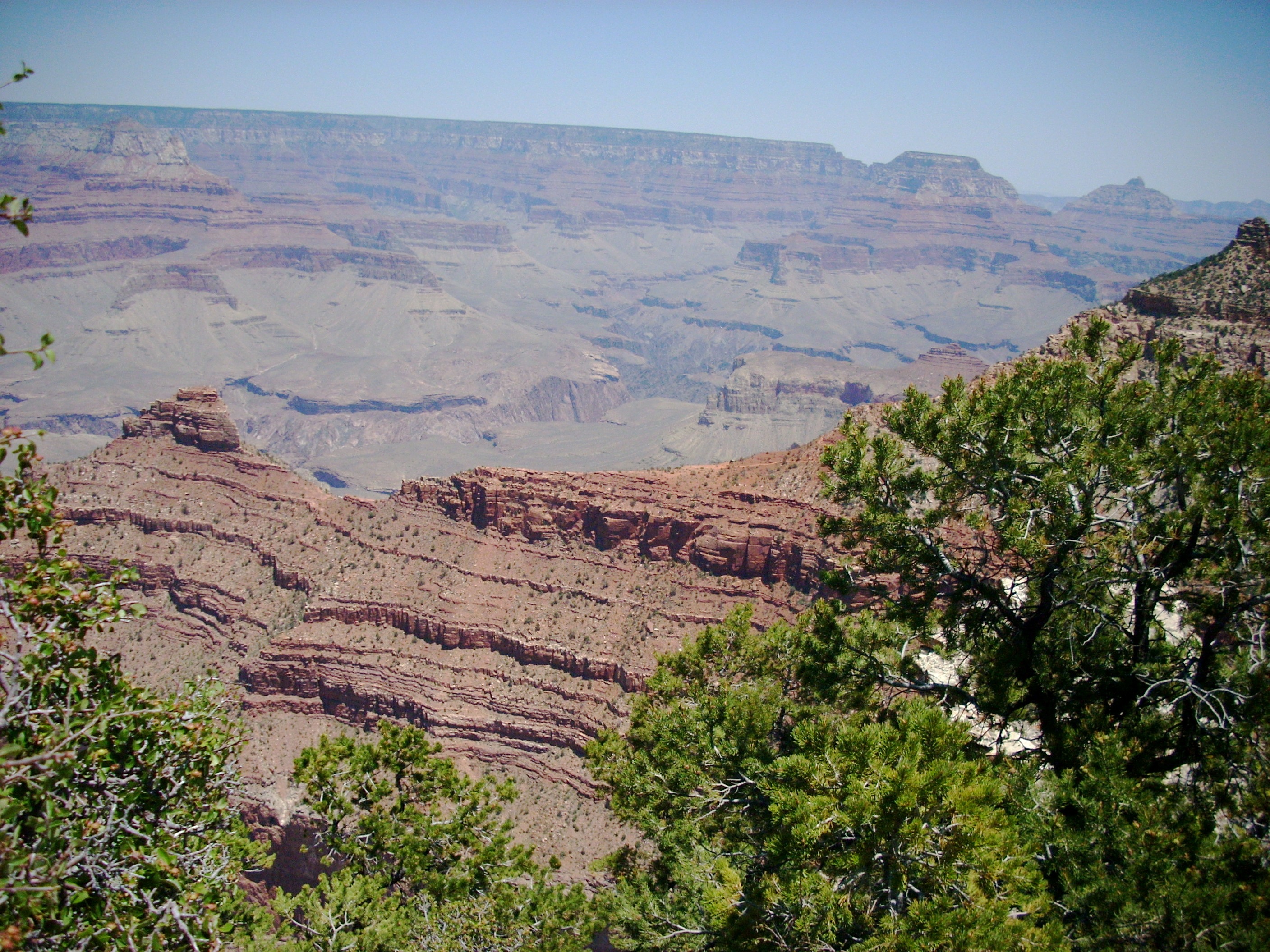
North Rim |
|
| Hiking | South Rim | West Rim | Boucher | Bright Angel | Hermit | Grandview |
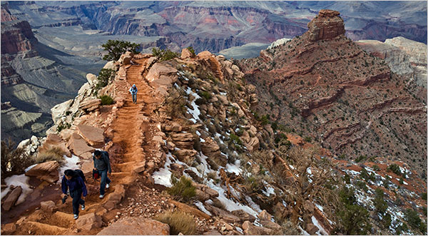
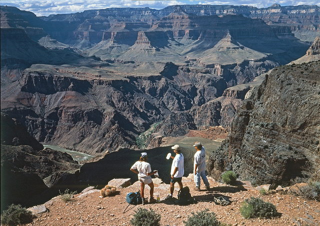
In a park of spectacular trails, most hikers consider the 6.3 mile South Kaibab the most spectacular of all. There are two reasons for this. First, all the other trails in the Canyon (except Grandview) were originally game trails, then Anasazai and Havasupai trails. They were chosen for efficiency. There are no easy routes from rim to river, but those other trails were chosen to be the easiest possible. The South Kaibab was built in 1924-25 by the National Park Service to be as scenic as possible. They weren't worried about ease of use. They wanted one breathtaking vista after the next. All these trails drop very quickly, but the South Kaibab drops quickest of all. Second, all the other trails follow stream drainages down. They zig and zag back and forth from one side of the stream to the other. They thus hug the walls. Your views look out across the canyon to the North side, but looking immediately to your left and right, you see mostly walls, flanks, and shoulders. The South Kaibab is just the opposite. It follows ridges, outcrops and promontories. You get the same north canyon views as the others, but you also get great views looking up and down the Tonto Plateau and the south walls. Paradoxically, this means that even though this is a shorter trail, it takes longer to hike because you keep stopping for photos or to admire the view. As just these top two scenes show, they each demand that you stop. If you try to keep hiking while gazing out over the abyss, you'll inevitably trip and fall. |
 |
 |
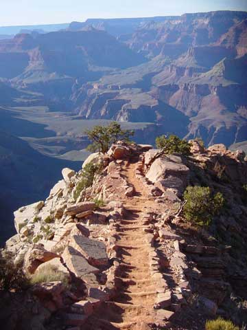
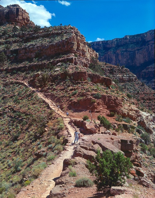
To reach the South Kaibab Trailhead, take the Village Shuttle to the Visitor Center, or drive in from Tusayan to the Visitor Center, then take the East (Kaibab Rim) Shuttle (orange). Just a few yards off the parking lot is the trailhead, shown here at left. The slightly darker pavement in the lower right corner is the South Rim Trail heading westward. The South Kaibab immediately begins descending through a specatacular series of switchbacks. The photo below right looks up toward this trailhead. You can see how the park service blasted these switchbacks out of the sheer rock of the Kaibab Limestone. The trail continues to drop all the way to the river, but the longest and steepest sustained drop is this initial series of switchbacks. |
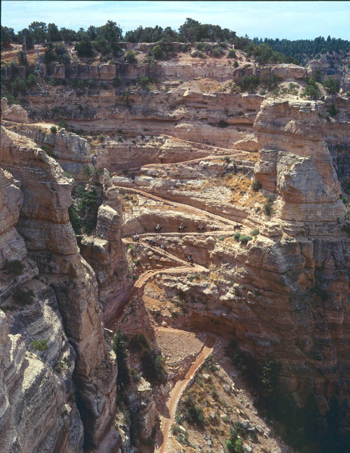
This was the scene of one of the Grand Canyon's most incredible feats when 42 Havasupai carried eight steel cables, each one 550 ft. long, 1.5 inches in diameter and 2,320 pounds, down to the Colorado River to use in building the Kaibab Suspension Bridge. Donald Hughes, a park ranger at the time, described it as "looking like some giant squirming centipede." Accounts of the day indicate that getting those cables around the bends in the switchbacks was a major challenge. The Havasupai carried one cable at a time down to the river, then all 42 came back to the parking lot and hoisted the next cable onto their shoulders. They made four round trips a day and carried all eight cables down in two days. In this photo, if you look carefully you can see the mule pack train on the way up. The trail at bottom center is disappearing off the picture. It will run along the side of the cliff and then emerge onto Cedar Ridge, also known as The Razor's Edge. |
 |
The Razor's Edge, probably the single most breathtaking quarter mile in the Grand Canyon. This photo is taken looking down on the trail from from Mather Point. That's O'Neill Butte at the far left of Cedar Ridge. The South Kaibab Trail follows the knife edge all the way out, before dropping down to the right (out of sight in this photo) and coming to Cedar Plateau (often mistakenly referred to as Cedar Ridge; the actual Ridge is what you're looking at here). Some of the most scenic panoramas are seen to the left and right as you hike across this knife ridge. However, if you're coming back up in late afternoon, keep your eyes out for approaching storms. You cannot allow yourself to be caught out on this ridge during a thunderstorm. You can either wait down on Cedar Plateau until the storm passes, which is usually pretty quickly, or if it's still downriver far enough and you have enough remaining energy, speed up and race across ahead of it. It's safe back against the cliff on the switchbacks. Just below O'Neill Butte the trail hugs the cliff (see photo two frames down). Storms come in from the West, so you might take refuge along that cliff. You'll still get wet, but the rain pounds down on the west face, with a much lighter drizzle on the east face. |
 |
 |
This is an early Spring photo of The Razor's Edge from out on the ridge itself. It's a beautiful hike in the cooler Winter months, except that the switchbacks at the top are often packed with snow and ice, making it dangerous. By late April that ice and snow is mostly gone except for a few small patches on the shady sides of ridges, as seen here. From this vantage point, it's obvious the shoulders of the trail extend out three feet or so, but when you're down on the trail, you can't see that. There's the optical illusion of your hiking along a razor thin edge with steep dropoffs on both sides. It can be a dizzying sensation. If you look carefully, below the O'Neill Butte, you can see the trail angling down to the right and disappearing out of sight. The photo below left shows that same trail coming around the base of the butte. |
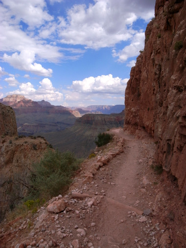 |
There is absolutely no water on the South Kaibab Trail. Most of the weight you'll be carrying will therefore be water. You need to ration it carefully. We recommend at least four insulated double wall stainless steel thermoses. Not plastic, and not single wall. We recommend filling those with ice and ice water back at the Yavapai Cafeteria or wherever else you eat breakfast. Use one on the way down, one during your lunch stop, and the other two on the way back up. During the Spring and Fall months the South Kaibab is enjoyable even with the steep climb out, but in June, July and August it becomes an inferno. People routinely run out of water and have to be rescued. If you were hiking all the way down to the river, there is water at the Bright Angel Campground. If you take the Tonto Trail over to Indian Gardens and hike up the Bright Angel Trail, there is water at Indian Gardens and at the water huts on the way up. This photo is taken along the cliff below O'Neill Butte, where we recommend taking shelter during late afternoon thunderstorms. |
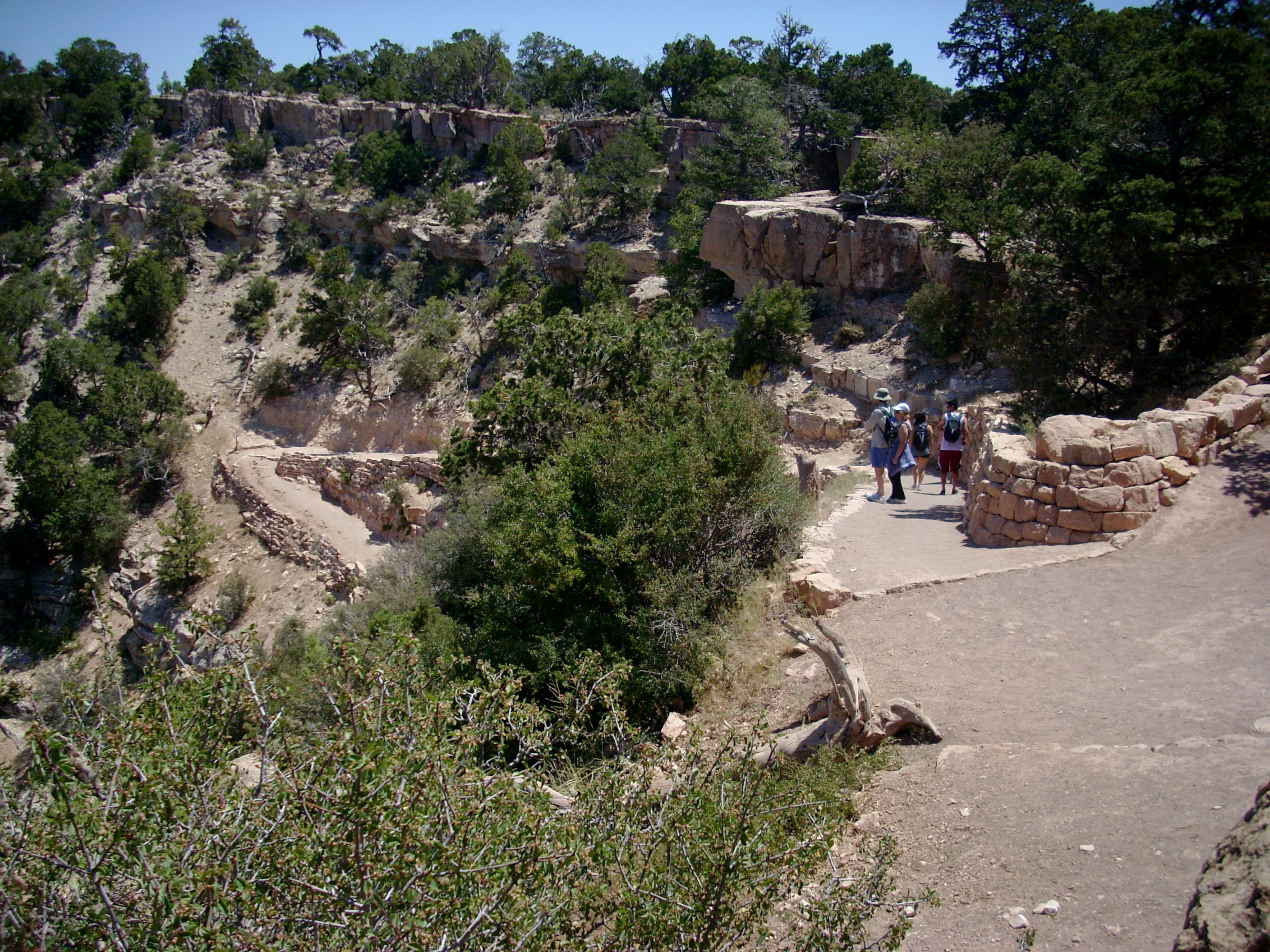
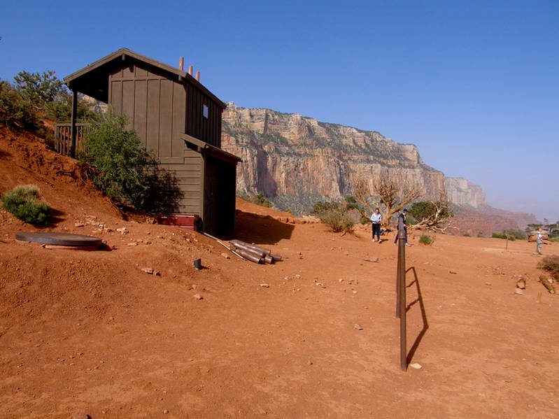
You need to plan your trip carefully before you start. There are several turnaround options. Cedar Pleateau, often called Cedar Ridge by mistake (the ridge is above it), is 1.5 miles below the rim, for an elevation drop of 1140 ft. If you turn around there, you'll have a three mile round trip. Cedar Plateau is the most common turnaround point, but the scenery beyond it gets even more spectacular, so you might consider going on. Skeleton Point is another 1.5 mile, down another 900 ft. This would give you a six mile round trip. Beyond that, Tipoff is another 1.4 miles, down another 1220 ft. So if you hike from the rim all the way to Tipoff you'll be going 4.4 miles down, for a round trip of 8.8 miles. This also means that from Tipoff back to the rim you would be climbing 3260 ft. The only pit toilets on the trail are at Cedar Plateau and Tipoff. The other points are marked by signs. The photo here at right shows the Cedar Plateau ("Cedar Ridge") stop, with its pit toilets. Probably 70% of all day hikers turn around here. |
 |
 |
This is Skeleton Point, the furthest down rangers recommend anyone hike in June, July and August unless they're staying overnight at Phantom Ranch. Notice to the left you can see the Colorado River. If you look carefully, just above the head of the girl on the left you can see a long narrow patch of cottonwood trees. That's Bright Angel Campground and the beginning of Phantom Ranch. |
| This is the second set of spectacular switchbacks on the South Kaibab. It takes you from Skeleton Point down to the Tonto Plateau and The Tipoff. Think carefully about this before you start down. Remember you're going to have to climb back up. The Park Service does not recommend that day hikers in June, July and August descend below Skeleton Point. The name Skeleton Point came from these switchbacks. Over the years, numerous mules have lost their footitng and fallen to their deaths here, their skeletons bleaching in the sun far below. | 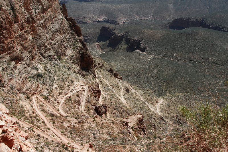 |
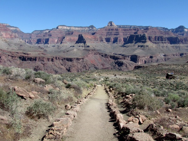 |
This photo shows the trail descending to The Tipoff. There are no switch backs between Cedar Plateau and The Tipoff. This broad ledge you're coming down to is the Tonto Plateau, which extends through the entire length of the Grand Canyon. That other trail you see cutting across the Plateau is the Tonto Trail, which runs along the Plateau and connects all the rim to river trails. You could turn left here and hike over to Indian Gardens, then up the Bright Angel Trail to the village. This is the absolute furthest down average hikers should come before stopping for lunch and then heading back up. Note the pit toilets over to the right. There's also an emergency phone here. From here, the trail drops steeply down to the river, the suspension bridge, Bright Angel Campground and Phantom Ranch. |
| This photo looks down from The Tipoff to the river. That's the famous Black Bridge, the suspension bridge crossing over to Bright Angel Campground and Phantom Ranch. This is the third major set of switchbacks and while, down this low in the canyon you don't have quite the views, these are every bit as hair raising as the previous two sets. | 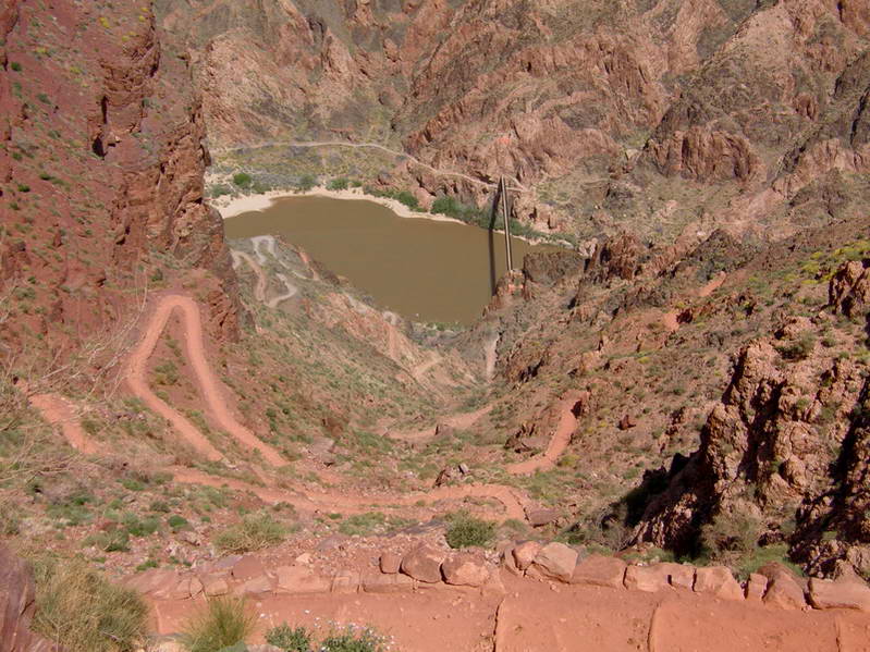 |
 |
This what you'll see as you hike back up. The staircasing of the steeper sections of the trail help, but there is a problem. The steps were carefully designed for the average mule stride, since the mule pack trains down to Phantom Ranch and back use the South Kaibab. But this created steps which do not match the human stride. You cannot cover one step with one stride. You are thus forced to take shorter strides, two on each step. This feels awkward when you have to maintain it for a quarter of a mile or more. It's much more tiring than a normal stride. |
|
|||
|