Chisos Mtn Loop
| Route 66 | Cities | Beaches |
|
Chisos Mtn Loop |
|
|
The Chisos Mountain Loop is one of the great backpacking experiences in America, but the mountain poses certain problems you must deal with well ahead of time. The biggest of those is Water. Youth groups or families cannot do this trail in Autumn, Winter or Spring due to school (unless your school officially sponsors the trip and grants excused weeklong absences, which is unlikely). During the Summer, which is the only time you can do it, there is absolutely no water on the mountain. It is at least a three night, four day circuit, and really should be done as a four night, five day trip. But a person requires an absolute minimum of one gallon per day, which in this 100 degree heat is cutting it close. |
This means for one night on the trail for 10 students and two adults you will need 12 gallons. And if you do the full four nights you'll need 48 gallons. Obviously, you cannot carry this. We have watched groups try various strategies. The only choice that seems to us to make sense is to pay a local service to horsepack your water. They come up the Blue Creek Trail from the Homer Wilson Ranch. For 12 people for four nights this pack train service will cost about $300, or about $30 per person. These arrangements must be made ahead of time, and you'll have numerous forms to fill out for the park service. Start the previous September to make sure you can get the dates you want. Do Not Wait Until Spring. |
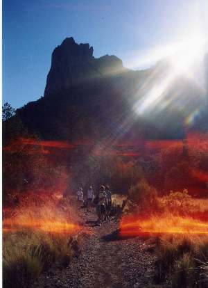
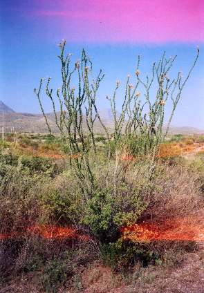
Once the water issue is resolved, you need to plan your itinerary precisely, because the back country office will assign you specific campsites and there is a ranger who stays up on the mountain, roaming around to make sure you stay where you're assigned. This might seem obsessive, but three problems motivate the rangers. The first is the Peregrine Falcons. You'll be up there during nesting season, and they have certain campsites and trails off limits to protect those magnificent but delicate birds. They are checking to make sure no one violates those parameters. Second, 90% of their rescue operations involve people running out of water. Knowing this, they try to check on everyone to make sure people have the water they need. Third, bear and mountain lions roam the mountain. Rangers continually patrol to make sure they know where the animals are in relation to where the people are. You don't need to worry about these problems. You've already taken care of water. We're going to suggest trails and sites which avoid the falcon issue. And with 12 people you're not in danger from either bears or mountain lions, as long as you keep the group together on the trail and in camp. But let no one wander alone. The odd looking plant to the right is an Ocotillo, a cactus with 15-30 thorny stems reaching upward, bearing flowers along their upper thirds. Above, the picture to the left shows our group heading up across Juniper Flats about a mile above the lodge. The fiery shadows are an optical illusion caused by the intense sun and heat. They can be seen in several of our photos, but notice they do not appear at higher altitudes, where temperatures are cooler. The upper right view shows the trail just below Emory Peak. |
 |
 |
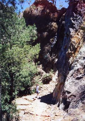
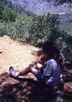
The Laguna Meadow Trail heads up the mountain from behind the store across from Chisos Mountain Lodge. But we suggest you park the van there, then walk up behind the lodge and head out the driveway to the adobe style cabins. The trail comes right past the paved turnaround. Joining it there saves you a quarter mile climb. You'll immediately find an intersection, with the Laguna Meadow Trail going to the right. This occurs below the water tank, so if you pass it on your right, you've missed the turnoff. This is not an especially difficult trail but it has three sets of switchbacks which will challenge you. Most of the trail is in shade, and you should be hiking it in the morning. You're only walking 3.3 miles. We suggest a stop at one and two miles. At the end of mile three you are entering Laguna Meadows, and for three quarters of a mile you pass one campsite after another, all numbered with metal signs. You and the backcountry ranger will decide exactly which sites you'll be assigned. Assuming you make your reservations early, you'll have your pick, so most of the decision will depend on how many are in your group. You should pitch camp and fix lunch. Be careful to follow all proper safeguards on preparing and storing food. Then we suggest you strap on your buttpacks with water and cameras and dayhike the Blue Creek Canyon Trail down to Cedar Spring. This is a spectacular hike, but once you start down, remember you have to retrace your steps. If your legs or feet start complaining, or the heat starts bothering you, stop and rest, then start back. The view to the left shows the trail just starting up from the intersection.
|
|
Next morning you have 600 feet to climb and 4.7 miles to hike. But the last two of those miles will be along the famous South Rim, where you'll look out over breathtaking distances deep into Mexico, and probably watch the Peregrine Falcons teaching their hatchlings to fly. Just underneath you, down a thousand foot cliff, are the falcon nests. We suggest stops at SW Campsite 3, the composting toilet at SW Campsite 4, and SE Campsite 2. You'll stop and pitch camp around at Northeast Campsite 4, which in our opinion is one of the two or three most spectacular campsites in the nation. After setting up camp and fixing lunch, you'll spend the whole afternoon, camera in hand, watching the falcons and admiring the view. On the third day, life gets easier. You carry the backpack 2.4 miles down to Juniper Canyon Campsite. After setup and lunch, you'll dayhike the Juniper Canyon Trail down to Upper Juniper Spring, where you'll be looking up eastward at Lost Mine Trail and up westward to Northeast Campsite 4, where you spent last night. The fourth day, you'll backpack two miles over to Emory Basecamp. After setup, you'll climb Emory Peak, which at 7825 is the highest point in the park and one of the two highest peaks in Texas. The approach trail from the basecamp is one mile, so your round trip is two miles. Plan on fixing lunch up on top, so you can eat leisurely while enjoying a 360 degree view that is one of the best in America. In the photo to the right, notice far in the distance, down in the crater, the cone formation jutting up and the lodge and campground below it. On this entire five day trip, they are usually visible that direction, while the Rio Grande, Santa Elena Canyon and Mexico are often visible looking South.
|
 |
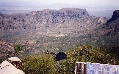 |
You could do Emory Peak as a nine mile round trip day hike from the Basin. Hit the trail no later than 9 a.m. so you're on top before the full heat rises around noon. The photo at left is taken from the peak. That's The Cone in the center, with the lodge just to this side and its three motel like additions extending to the left. Further down to the left is the campground. Disappearing off the photo to the left is the darker green thread which is the creek and the trail down to The Window. Looking back up this direction from the cone you can see the gradual slope the trail climbs, then, disappearing from view below The Rim, is Juniper Meadow. The Switchbacks are directly below us and not visible. If you climb up here as a day hike, we recommend stops at the top of Juniper Meadow just as you begin the Switchbacks, and at the trail junction where the Emory Peak trail turns off to the right. The base of The Switchbacks is about two miles up, and the Junction is about 3.5 miles up. The final ascent is a very steep mile, but is hiked without ropes. The photo shows dramatically the volcanic crater and the valley floor in its center. The Gap at right is where the road climbs out of The Basin and winds down to Panther Junction. That's desert way out there beyond the rim in the distance. |
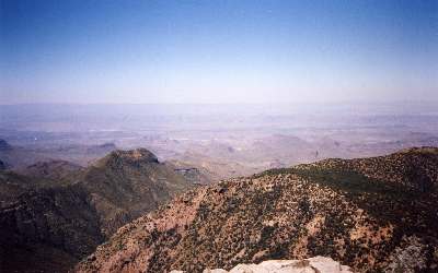
| This photo is also taken from
Emory Peak, looking exactly the opposite direction. Immediately below
you is The South Rim. That's the Blue Creek Canyon Trail carving down
in the middle foreground. Beyond are the Chisos Badlands, which extend
to the Rio Grande in the far distance. Notice the clear air in The Basin, and the heavy
haze drifting down along the Rio Grande. That's from the 100 or so factories
which have grown up on the Mexican side of the river between Presidio
and El Paso. Those Badlands make great three season backpacking, the most
spectacular trail being the Chisos Mountain Outer Loop. But from June
1 to September 1 the area is closed due to 120+ heat and no water. However, several outfitters
provide jeep trips into that area. If we swung the camera to the West, we would show
a clear view of the park's Western boundary, with Study Butte and Terlingua
barely visible beyond the Badlands. If we swung it to the East, we would
show a clear view of the middle part of the park, with Lost Mine Peak
nearby and Panther Junction and the Badlands visible extending down to
Cottonwoods and the Eastern canyons. |
 |
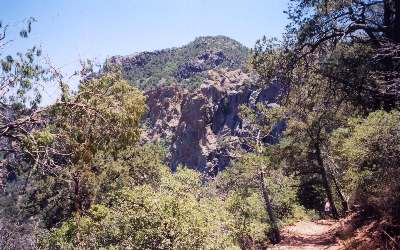 |
If you're backpacking, the fifth day is easy. You'll coast four miles down to Chisos Mountain Lodge. Don't forget to take the cutoff at the first adobe cabin, following the paved driveway over to the lodge. This saves you a quarter mile loop down and up to the store parking lot. Even though the route is all downhill, we suggest stops at Pinnacles 3 and Juniper Flat 2. The switchbacks can punish your feet just as much going down as coming up, and after four days your feet are probably vulnerable. You will also want to stop for several photos. The photo to the left shows the trail just a few switchbacks below the rim. Emory Peak is behind and above us. After five days in the heat, carrying packs and navigating switchbacks, we're ready to reward ourselves. So as we come off the trail, we like to relax in the air conditioning at Chisos Mountain Lodge Dining Room and eat a lunch prepared by someone else. They have great milkshakes, too. |
|
|||
|