| Route 66 | Cities | Beaches |
|
|
| The Lost Mine Trail is a must. It's not only a great warmup after you've done the Window, but it's an epic challenge in its own right. You're going to climb 1250 feet in 2.4 miles to one of the most spectacular views in North America. This gives you a 4.8 mile round trip and an absolutely breathtaking lunch stop. You'll need a roll of film and pair of binoculars, and a disposable panorama camera would be a good investment. A buttpack (fannypack, beltpack, etc.) is ideal for these desert mountain hikes because anything high on the back will produce heavy perspiration. | The usual precautions apply here. Start early to reach the top before the heat sets in. Apply 45 pf sunblock and reapply it halfway up and just before starting down. Carry two Nalgene water bottles or a camelback water pack. Pack a good lunch. Wear one thick and one thin pair of socks, talc the feet, the inside boot soles and the socks, and change socks halfway up and on top. Carry hiking sticks. Wear a good pair of sunglasses. Don't make this a race. There are several great stops on the way up. Pause there for a drink and a few photos. Savor the day and relax. |
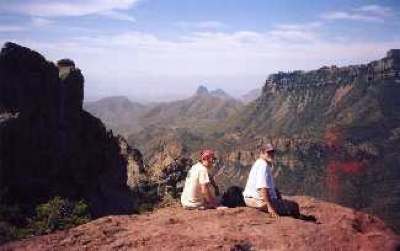
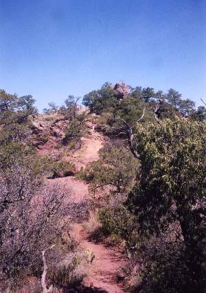
To get to the trailhead, load into your vehicle and drive up the switchbacks as if you're going to Panther Junction. Just before the road tops the crater's edge and heads back down the other side, the Lost Mine parking lot turns off to the right. The trail begins on the uphill side. It doesn't waste any time, either. Immediately you head up a steady climb through juniper, oak and pinyon pine. While the path is wide and well groomed, it relentlessly ascends the hill. You get your first break when you emerge out of the trees onto a level shelf with a bench and breathtaking view (right) stretching across mountains, deserts, the Southeast Rim, the Rio Grande, and beyond far into Mexico. You'll need a panoramic lens or camera to capture it adequately, and you still won't be able to fit it all in. To your middle right, Juniper Canyon descends from the South Rim. If you have a pair of binoculars, you can find the trail coming down. Further to the right are Toll Mountain (7465) and Casa Grande (7825). The huge, bulky formation in the middle distance is Elephant Tusk (5249). Way in the distance, that ribbon of green amid the expanse of brown is the Rio Grande. |
 |
 |
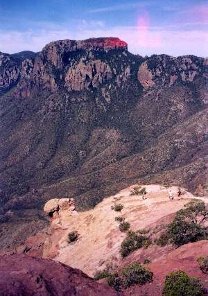
This would be a great lunch stop. Unfortunately, it's not lunchtime. You have a long way to go. Just beyond the bench, the trail resumes climbing, and it keeps on until it reaches the top. The views keep getting more spectacular, which gives you an excuse to keep pausing at the switchback turns to take pictures or just gawk. The switchbacks are also out in open sun, and from midmorning on that mountainside starts heating up. Halfway you might want to reapply some sunblock and change socks. And every time you stop to admire the view, you might want to take a good mouthful of water, whether you feel thirsty or not. Toward the top, the trail steepens and becomes rockier. Eventually, you'll top out on the long, narrow ridge. This is not really Lost Mine Peak (7535), which many hikers assume. That would be the rocky point jutting straight up immediately to your East. To climb that, you' ll need ropes. This is Lost Mine Ridge, a mere 6850. |
|
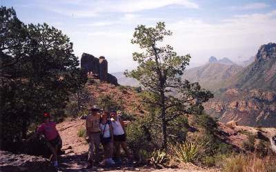
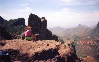
But fear not. Lost Mine Ridge is hairy enough. With a good pair of binoculars, you can pick out the mouth of Santa Elena Canyon, and the Sierra Ponce Wall and Chihuaha Mountains over in Mexico. You've climbed 1250 feet in 2.4 miles, and your reward is one of the greatest lunch stops in North America. You can stretch out on the rocks, watch the Peregrine Falcons riding the air currents, take pictures, sleep or just enjoy the view. There are various huge rocks to scramble around on, and from several vantage points you can see your campsite far down the valley, along with the road leading up from it. The photo at lower right is foreshortened by the telephoto lens. But the rock outcropping drops off 2000 feet to the valley below, and the South Rim in the distance is another 2000 feet above us. The four kids walking out on the rock are not in as much danger as they seem. Just behind the visible surface, a wide ledge about four feet down would catch anyone who fell. |
 |
 |
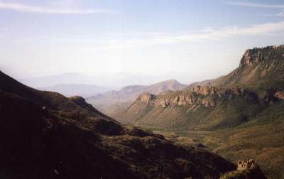
You'll notice there are no real clouds in the sky, only high wisps of cirrus. This is very thin air, and you can burn to a crisp pretty quickly with the sun reflecting off all those rock surfaces. No matter how much sun block you apply, you don't want to spend more than an hour up here.We've seen people get bad burns on these peaks and ridges. Be especially careful of your nose, ears, neck and forehead. You should also change socks and retalc. On the trip back down, you'll be walking on very hot sand and rocks, and heat buildup causes blisters. It would be a good move to sit there and eat lunch in your bare feet, allowing them to cool down and dry out. As you descend, you might pay attention to the trailwork done in 1940 by the Civilian Conservation Corps. The Big Bend National Park trail system is considered one of the best examples of their excellent craftsmanship. The water bars, steps, switchback turns, culverts and walls are all still in very good shape. There have been minor repairs, but the basic work is still in place. |
 |
|
|||
|