Continental Divide Loop
| Route 66 | Cities | Beaches |
|
Continental Divide Loop |
|
| Getting There | Lodging | Restaurants | Hiking | Backpacking |
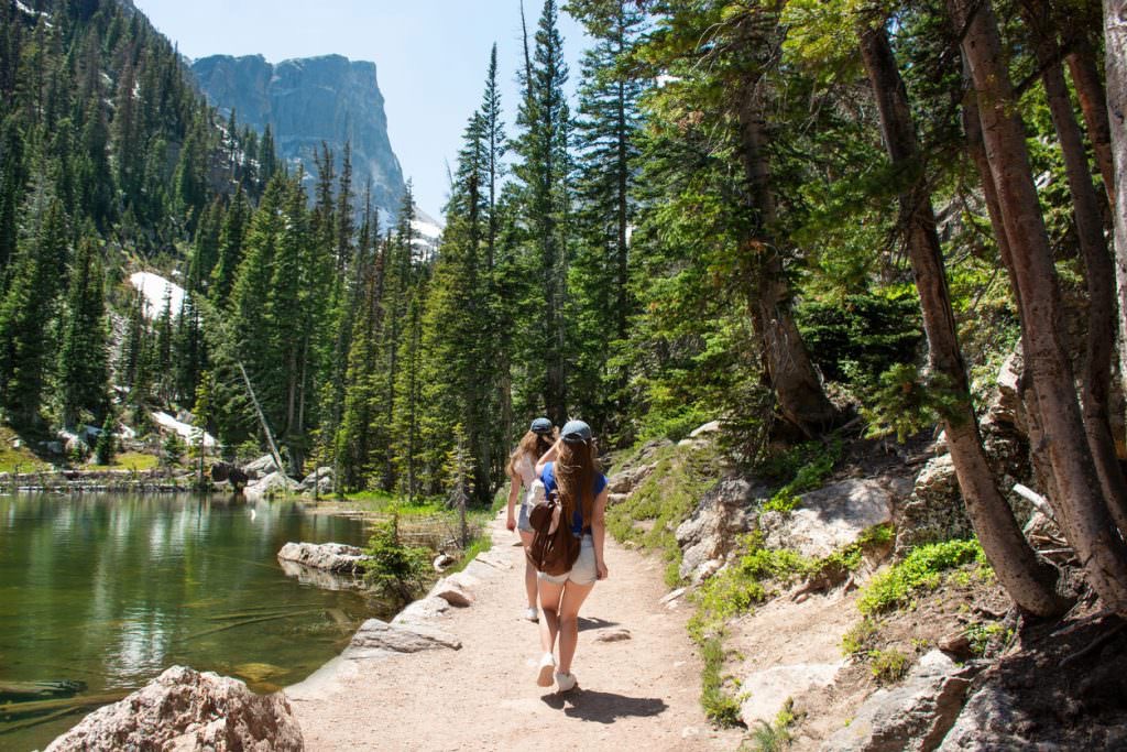
The Continental Divide Loop is the park's most famous backpacking trip, the one hard core backpackers come from all over the U.S. and Europe to hike. This is a circle that begins and ends in Grand Lake, and includes every type of scenery the park has to offer. We recommend you take I-25 up from Denver, turn off at Loveland, and enter the park through Big Thompson Canyon. You might stop in Estes Park for a few hours or overnight, then take Trail Ridge Road over Milner Pass, stopping at the Visitor Center at 12,000 ft. Coming down on the west side of the park, camp that first night at Winding River Resort, just outside Grand Lake on your right. You're across the road from Kawunechee Visitor Center, where you pick up your trail permits. Make reservations at Big Meadow, Timberline (two nights), July, North Inlet Junction, and Cascade Falls. This will give you a seven day loop with two side day hikes. But you need to make reservations at Winding River and with RMNP several months in advance. This the most famous route, and there's only a two month window to hike it, so the permits are in demand. Your first day will be easy, a nice warmup for what's to come. The trail follows Tonahutu Creek and is almost level. |
 |
| Continental Divide Loop | Never Summer | Indian Peaks | East Inlet | Big Thompson Loop | Mummy Pass | Wild Basin |
 |
You camp that first night at Big Meadow (see above). The actual campsite is on a slightly raised island with trees. Tonahutu Creek flows past, providing you with water. You'll watch elk and moose foraging in the marsh while you fix dinner. As the sun angles down, you'll see clouds of mosquitoes rising from the grass, which will fill you with concern, but you'll also see dragonflies appear and devour hundreds of mosquitoes. It's an amazing sight. Once the sun totally sets, and the chill sets in, all the insects vanish. You can sit around your campfire in your hooded sweatshirt in peace. You do need to hang food and take all the usual precautions. But it's a great campsite. The next morning the trail circles the meadow and starts to climb. By mid day you reach Granite Falls, in photo at left. There's a campsite here which is ideal for a lunch stop. Then it's another several hours of climbing through deep forest to Timberline campsite. |
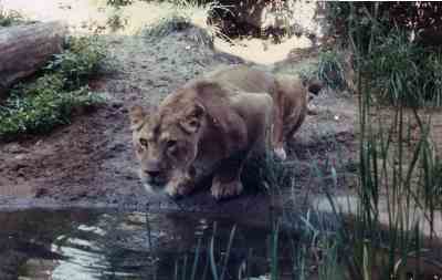
This is a beautiful site. Across the creek is a towering jumble of cliffs and rocks. Two nights when we camped there, a Mountain Lion prowled those cliffs and rocks, twice coming down for a drink (photo right). Once, just at dawn, a Moose carried off the backpack of one of our group. He scrambled out of bed and chased the moose half a mile down the trail until it dropped the pack. Elk stroll through the site and large birds ride the air currents overhead. We advise you to stay here two nights and hike up a side trail to Haynack Lake while adjusting to high elevation. When you leave here, you're going to climb the longest and steepest ascent in the entire park. You'll be climbing Flat Top Mountain (12, 324 ft.), hiking across it, then descending the other side to July campsite. The climb up from Timberline is a relentlessly steep grind. You leave tree cover behind as soon as you leave Timberline campsite, so prepare to shed some clothing layers as the morning warms up. As you climb, the views open up, and eventually you'll be looking 360 degrees over the entire park. You could shoot several rolls of film, and you'll pause several times to rest your legs. But you can't stop too long. |
 |
 |
It is essential you get across the top of the mountain and at least partway down the switchbacks before 3 pm, because right about then the daily weather erupts. Hail, sleet, ice, rain, snow and wind will be bad enough. But the real threat is lightning. It's dangerous. You'd be the highest point on a treeless plateau at 12,000 ft. You'd need to find a depression, take off your pack, and lay down. It will take about four hours. It's a mischievous trail, with several false summits. You'll feel elated at having reached the top and then come over the rise and see that you have yet another climb ahead. But you eventually top out on the Continental Divide. The views are unbelievable. Since by now it's probably early afternoon, you probably see weather rolling in from the West. You need to make it along the Divide to the intersection, where you can take the North Inlet Trail down, before that storm hits. The photo at left shows the trail climbing. The photo below left shows the trail beginning its descent into the North Inlet drainage. |
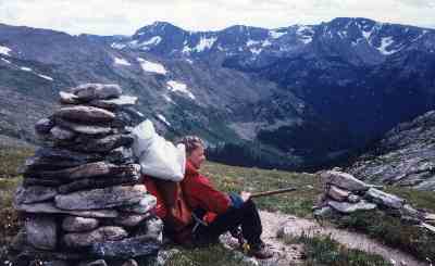
The trip across the top is surreal. You're crossing tundra, surrounded by patches of snow. The sun is bright but the wind is icy. The trail is marked by rock cairns, seen in the photo at right. You'll be entertained by rockchucks, who live in burrows or rockpiles. They whistle at you as you pass. You can put your pack down and chase them across the rocks and they'll disappear and reappear behind you with a whistle, cheerfully playing hide and seek as long as you want. Just to your left (east), you can walk over to the edge and look down on Glacier Basin. And, after a lunch stop (photo right) at the main trail junction where the Bear Lake Trail heads down to Glacier Basin and the eastern section of the park, you can actually see the weather fronts forming down in the valleys to the west. Don't think that once you start down the switch backs (photo below right), your day is done. You can see July campsite below you, but the switchbacks are steep and footing can be treacherous, especially if you get caught in the afternoon rain. |
 |
 |
July campsite is so named because it is under deep snowdrifts until July. If you hike this in July or August you'll find the snow gone and the forested sites beautiful. We only stay here one night, but you could stay two and hike up to Ptarmigan Lake to fly fish for Cutthroat Trout. This is the site where mule deer graze right up to our tents and rockchucks rummage through our pots and pans. And that's with our food raised and all the usual precautions taken. We always serve Shepherd's Pie this night because it's our group's favorite trail meal, and this is the most exhausting leg of the trip. Like Timberline, temperatures here will really chill down as the sun sets and the breeze begins blowing cold air down off the snowpack. You'll need your down bags and hooded sweatshirts. But we also sleep really well here after the trek over Flat Top Mountain. Mornings here come late, because we're tucked down under the mountain and the sun doesn't reach this valley until 10 am or so. |
From here you can relax and just enjoy the trip. The trail is 100% down hill all the way into Grand Lake, past beautiful water falls, through deep pine forest. So we have time to play. The backpack on Day Five is the shortest of the trip, downhill two miles to North Inlet Junction. We get there by noon and set up camp along a great swimming hole. First, however, we take only our day packs and hike the 2.8 miles up to Lake Nanita, in a bowl below Mt. Andrews (photo, top right). It's a great stop for a late lunch. The trail switchbacks up past those other lakes. This is another fly fishing site with Cutthroat Trout. You can easily catch dinner here. The hike back down puts us in camp by 3 pm, and we relax with a cool dip in the swimming hole. Day Six we hike three miles down to Cascade Falls. We can either play in the pool below the falls or explore off trail up either Nisa Mountain (10,788 ft.) or Mt. Enentah (10, 781 ft.). Day Seven we hike on through Summerland Park, an old resort, and out to the Kawuneeche Visitor Center, where we officially check out. |
 |
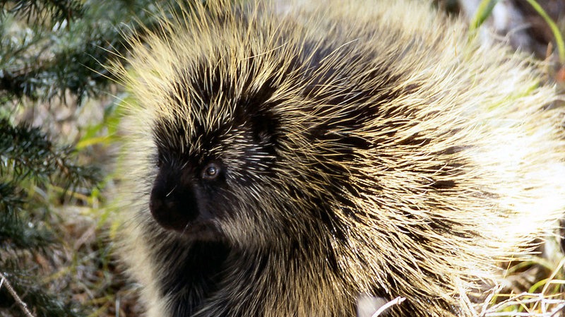 |
In the North Inlet campsites, your biggest pest will not be Bear or Moose but Porcupine. They're fascinating and cute but they can also be annoying. They'll gnaw on your boots for the salt (left by your perspiration). They'll chew holes in your packs. They'll rummage through your pots and pans. They move slow, but because of those dangerous quills they have no fear. You can yell or brandish a hiking stick and the Porcupine will just look at you with a puzzled expression. If you get too close it will raise that tail to let you know you're beginning to annoy it. After you check out with the ranger at Kawuneeche Visitor Center, you might consider a night at Rapids Lodge in Grand Lake. It's a great Old West town. Once you've had a hot shower and a few good restaurant meals, you might be up for either another backpacking trip or a series of hikes. There are several tempting options. |
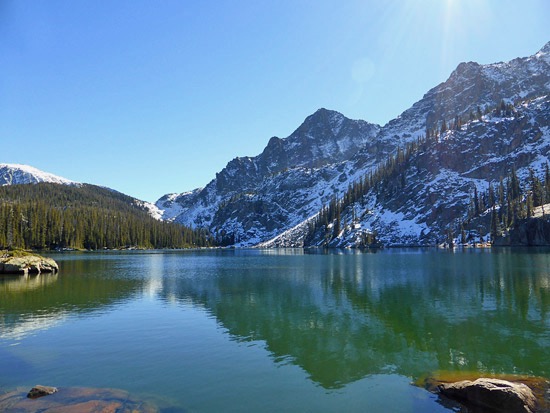
From Grand Lake, you can backpack out East Inlet Trail to Spirit Lake. There are six beautiful campsites up that valley. It's an out and back trip, but you could bushwack above Spirit Lake and drop down into Thunder Lake and the Wild Basin trail network, where you'd come out at Allens Park. You could backpack out the East Shore Trail, which follows the shores of Grand Lake, Shadow Lake, the Colorado River and Lake Granby to a cluster of campsites at the base of Mt. Hale. From there, the Roaring Fork Trail leads up into the Indian Peaks Wilderness. Neither of these trails gain much elevation (see photo, right) so would be relaxing after the Continental Divide Loop. You could spend your time swimming and fishing. When it comes time to leave, you can drive out via Route 34 South to I-70, or you can drive back over Trail Ridge Road and spend a night in Estes Park. |
 |
|
|||
|